The exact date of the construction of Stanely
Castle to the south-west of Paisley is unknown,
but it may have been built in the early fifteenth
century when the land passed by marriage from the
Dennistouns to the Maxwells of Calderwood. In
1629 the Maxwells sold their Stanely property to
Lady Ross of Hawhead. It passed by marriage to
the Boyle family in the middle of the 18th
century. David Boyle had been made the first Earl
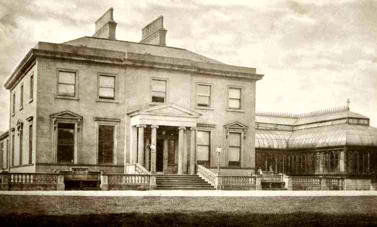
of Glasgow in 1703 and the family's main estate
was centred around Kelburn Castle at Largs. In
the 18th century, part of it was being used as a
schoolroom where local children were taught
reading, writing and arithmetic.By the 19th
century the family found themselves in serious
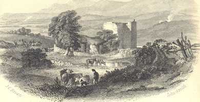
debt and Stanely Castle was abandoned and fell
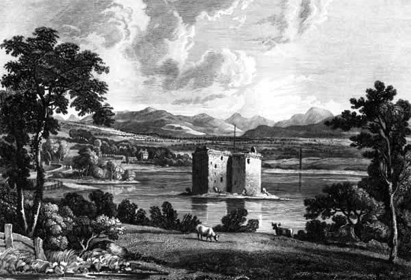
into ruin. In 1838 the Earl of Glasgow sold the
castle and surrounding land to the Paisley Water
Company for the construction of the reservoir in
which it now sits which supplied the people of
Paisley and its surrounding areas with fresh
water. Over the years, the reservoir level was
raised. It now submerges the lower portion of the
castle.
Construction
The castle is constructed in local freestone,
which shows very little sign of weathering. It
has been constructed of large, roughly squared
and hammer dressed blocks, which have been laid
in rough courses. Corbels and window margins are
dressed. A high proportion of masonry is cut and
dressed stone, especially in the interior.
Description
The castle is an L-shaped tower house of four
stories, which originally would have included a
garret, but it is clear that the castle was
constructed in two phases. The original castle
being a rectangular tower aligned NNE-SSW. To
this block was added a square extension or jamb.
When the jamb was added it was necessary to add
new openings into the new rooms. The castle was
entered by its only door which is on the east
side.
The first floor, and all upper floors were
reached by a spiral staircase in the northeast
corner. The ground floor was occupied by 2
compartments or cellars. There was a private
staircase in the south gable which gave private
access to the Hall above. The first floor was
occupied by the Kitchen in the Jamb, and the
great hall and a private cabinet in the main
block. The second and third floors each contained
two bedrooms in the main block and an additional
room in the Jamb. Each of these rooms contained a
privy and fireplaces.
Stanely has two storeys over the hall, with no
indication of rooms in the roof space. However it
is possible that one attic room or a pair of
small rooms could have been created. The Hearth
Tax return for 1691 lists eleven hearths. Since
the floors up to parapet level only account for
nine hearths, this strengthens the case for attic
rooms in the main block.

from Ramsay
Philip (1839) Views in Renfrewshire, with
historical and descriptive notice
THE barony of Staneley anciently belonged to the
family of Denzelstoun, or Dennistoun, of that
Ilk, as appears from a charter granted by King
Robert II. to Sir Robert Dennistoun in the year
13-12. On his death, it fell to one of his two
daughters and co-heiresses, Elizabeth, wife of
Sir Robert Maxwell of Calderwood. Subsequently,
it became the patrimony of a younger branch of
the family of Calderwood. In 1629, John Maxwell
of Staneley sold these lands to Dame Jean
Hamilton, widow of Robert, fourth Lord Ross of
Hawkhead ; and now they belong to the Earl of
Glasgow, as lineal descendant and representative
of that noble house.
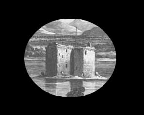
The Castle of Staneley stands about one mile and
three quarters south-west in a straight line from
the Cross of Paisley, and near the base of the
range of hills called the Staneley or Paisley
Braes, known also, at least in one part, as the
Braes of Gleniffer. The time when this structure
was built is hid in obscurity. It consists of a
quadrangular body, with a projecting rectangular
tower to protect the entrance ; has contained
four stories ; and is about forty feet in height.
A cornice at the top, the corbels of which
project considerably, gives an agreeable finish
to the pile. Though the external appearance
produces the impression
of considerable accommodation, yet the area
within the body of the Castle, owing to the walls
being five feet thick, is only thirty-six feet by
scarcely sixteen. The whole of the lowest story
has been vaulted, and in its walls are narrow
slits for the admission of light and air, and for
the purpose of defence. The apertures in the
upper stories are mostly of such a size as to
come under the designation of windows, and their
appearance indicates that they have been grated
even to the top of the building. Besides the main
stair, there is a secret one in the thickness of
the wall, leading to the second story from the
vault beneath. The principal entrance is on the
east side.
In the angle of the wall, immediately above it,
are vestiges of a projecting portion of the
parapet, through openings in the floor of which,
stones and other missiles might be thrown upon
the heads of those attempting to break open the
door. Appearances show that. the Castle has had a
court-yard, inclosed by a wall, and that it has
been surrounded by a moat, which was provided
with water by an artificial cut from
Staneley-Moor Burn, about a quarter of a mile
distant. A piece of adjoining ground, which long
bore the name of " the Orchard," formed
the garden.The Castle was unroofed in the year
1714, and it has ever since remained in a ruinous
condition.
In the memory of some aged persons, a school was
kept for many years in the low vaulted apartment,
at the north-east corner, where reading, writing,
and arithmetic were taught to the children of the
neighbourhood. The accommodation and the
remuneration were alike miserable. It is said
that the poor pedagogue was qualified for a
better situation, for that he was accustomed to
" amaze the gazing rustics rang'd
around" by a display of' his knowledge of
Greek and Latin. Be that as it may, we cannot but
sympathize with one who was doomed to pursue his
irksome vocation in a chamber so gloomy and
comfortless.
There is a tradition, that, towards the end of
the sixteenth century, an affray took place at
Paisley, in which Maxwell, the Laird of Staneley,
lost his life. The individual who dealt the fatal
blow was known, and Maxwell's two sons vowed
revenge. Long afterwards, when walking over
Staneley Braes, he was espied and pursued by the
sons. The man fled with his utmost speed, and
reached the narrow chasm of Gleniffer, where,
impelled by fear of the certain destruction which
awaited him. if overtaken, he sprang from the
edge of the rocks to the opposite brink. His
pursuers were unwilling to hazard their lives by
attempting the same feat ; and the time they lost
in descending to the bottom of the glen, and
climbing up again, enabled him to escape.
This person's Christian name was Robert, and, in
memory of his desperate leap, the spot has ever
since been called " Rab's Loup." In
support, so far, of this tradition, we find, from
an authentic record, that on the 3d of July 1584,
Robert Sempill, burgess of Paisley, and eight
other persons, were accused before the High Court
of Justiciary of having been guilty, " art
and part," of the slaughter of Patrick
Maxwell of Staneley, committed in the month of
January preceding. Very probably this Robert
Sempill was the " Rab" who took the
leap. Some of the panel's were "
repledged" to the regality of Paisley, and
the case with regard to the rest was continued to
the Justice-air of Renfrew. Ultimately, only one
of the accused persons, John Whiteford of that
Ilk, was brought to trial, and he was acquitted.*
In the field on the south side of the Castle are
the shaft and pedestal of an ancient stone cross,
which originally stood at the north-west corner
of Staneley Wood, about half-way between the
Castle and the houses of Darrochstock, and was
only of late years removed to its present site.
This remnant of antiquity is between four and
five feet high, the cross piece at the top being
awanting. Semple says, that when he examined it
in 1782, there were, on the west side, " the
figures of two lions near the base, and two boars
a little above." This was when it stood in
its original situation. At the present day, it is
so much weather- wasted, that the rude outlines
of some figures, on what now forms the south
side, are the most that the scrutinising
antiquary is able dimly to discern. On the edges,
some remains of wreathed work are still visible.
Semple calls this " a Danish stone,"
but he has not assigned any reason for ascribing
it to that people. It would rather appear to have
been one of the many devotional crosses for
travellers which were set up in ancient times.
The sculptured figures, perhaps, represented the
armorial bearings of the person by whom it was
erected. From this cross the neighbouring
farm-stead of Crossbar, corruptly called
Corsebar, may have derived its name. Staneley
Castle and Staneley Shaw, the Braes and the Dell
of Gleniffer, are names which have been rendered
familiar to every lover of Scottish song by the
poet Tannahill, of whom these were favourite
haunts. The traveller who visits these scenes
ought to extend his walk about a mile along the
brow of the hills to their highest eastern
summit, Duchal-law, so as to look down upon the
track of the Levern.
Though there are more celebrated landscapes in
Scotland, there are none which rival this in
towns, villages, mansions, and hamlets thickly
scattered ; and very few which excel it in
richness, natural beauty, and extent. The
accompanying View represents Staneley Castle as
it now appears at the south-western extremity of
the Reservoir which was lately formed for
supplying Paisley with water. The Reservoir has
given an entirely new character to the appearance
of the venerable ruin. They are mutually improved
: the fine sheet of water supplies the place of
bare uninteresting fields, and the Castle-,, yon
hoary veteran, grey in arms"imparts grace
and dignity to the scene.
|